API Available
Any map image.
Precisely georeferenced.
One API call.
Upload an unregistered map scan. Get back a fully georeferenced image aligned to the OS National Grid — metre accurate, world-file ready, GIS-ready.
POST /api/geovista/search
→ Preprocessing image...
→ Generating patch embeddings...
→ FAISS search (64 patches)...
→ MaxSim reranking...
✓ 3 matches found
→ Best: TQ3080 @98.7% confidence
→ BNG: 530000, 180000
→ Fine registration (LightGlue)...
✓ Aligned. RMSE: 0.73 m
Complete Georeferencing. One Endpoint.
From raw scan to GIS-ready output — a single API call handles the entire pipeline.
1
Your Image
Unregistered map scan — any format, annotations handled automatically
2
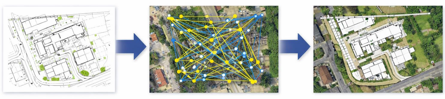
Locate
DINOv3 embeddings + FAISS vector search across full GB coverage
3
Align
SuperPoint + LightGlue keypoint matching with RANSAC homography
4
Output
Georeferenced image + world file ready for QGIS, ArcGIS, or any GIS
<10px
RMS pixel accuracy
GB
Full national coverage
BNG
Native CRS output
1
API endpoint
Everything you need. Nothing you don't.
Production-grade georeferencing engineered for GIS professionals and developers.
AI-Powered Location Finding
DINOv3 contrastive patch embeddings and FAISS vector search identify the correct OS tile from GB-wide coverage — no metadata or prior coordinates required.
Vista Search
<10 RMS Pixel Alignment
SuperPoint keypoint detection and LightGlue feature matching deliver precise geometric registration with sub-10 pixel RMS error, verified by RANSAC homography estimation.
Vista Match
GIS-Ready Outputs
Receive a georeferenced image alongside a world file, ready to load directly into QGIS, ArcGIS, or any GIS platform with zero post-processing.
EPSG:27700
Robust to Annotations
Annotation-aware preprocessing handles stamps, overlays, and hand-drawn marks — common across historic map collections and operational survey outputs.
Preprocessing
Ready to get started?
Get your API key through the Azure Marketplace, or try the interactive demo first.